Keywords: short-range weather forecast, local area, GPS, neural network, identification problem.
The GPS (Global Positioning System) is a satellite navigation system for ships
and airplanes to find their own locations. It has recently come to be used in
surveying in particular[
1]. Errors due to the delay of GPS radio waves are inherent
in the results of GPS surveying. Factors of observation errors are the locations of
satellites, the errors of receivers and those of clocks on satellites, and the delay of
radio waves due to the ionosphere, multipaths, vapor in the atmosphere, etc.
All the factors but the vapor in the atmosphere can be removed to a certain degree.
Because the vapor in the atmosphere is in a phantasmagoric dynamic state which
cannot completely be grasped with the present technology, it is difficult to remove
the errors due to the vapor-caused delay of radio waves[
2]. On the other hand,
research is being made to observe the vapor in the atmosphere by using the GPS[
3].
The object of the present study is the development of a local short-range weather
forecast system which makes use of the vapor-caused errors inherent in observation
data by the GPS[
4] and the neural network technology (Figure
23.1).
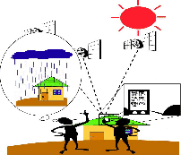
Figure 23.1: Schematic Illustration of the Study
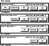
Figure 23.2: System Configuration
Firstly, in a preliminary examination, we selected the data items, where GPS data
identified the weather. As a result of constructing a system using the data items, we
have obtained from the preliminary examination, the "fine weather" and "rainy
weather" items have been almost completely indentified. Secondly, we conducted
the final examination considering with their results which we have obtained from the
preliminary examination. In the final examination, the weather was indentified by
the GPS data and weather factors. Measures were taken to grasp the maximum
delay of GPS radio waves caused in the troposphere, and the system was constructed.
The weather forecast system constructed in this study consists of four subsystems as
shown in Figure
23.1. The first subsystem was for sunny weather; second,
sunny/cloudy; third, cloudy; and fourth, cloudy/rainy. Each data set was first
evaluated in the first subsystem. If it was not for sunny weather, it was forwarded to
the second subsystem. If it was not for the sunny/cloudy weather, it was passed to
the third subsystem. If it was not for cloudy weather, it was passed to the fourth
subsystem. If it was not for the cloudy weather, it was considered to be for rainy
weather. As a result, other than the "fine/cloudy weather" item we have been able to
completely indentify all of the weather items.
It was ascertained in this study that local weather can be forecast in a short range
with GPS data. To make the system developed in this study practical, however, its
forecasting accuracy has to be improved further. The authors will raise the accuracy
by using the data of the Geographical Survey Institute of the Ministry of
Construction in Japan. Besides the authors will study further to develop a method of
forecasting weather over a longer range.
- 1
- T. Atsushi, H, Tsuji, "Easy, Simple GPS Surveying", Surveying Association of Japan, 1997.
- 2
- G. Thierry, G. Blewitt, "The Effect of Weather Fronts on GPS Measurements" GPSworld, 1998.
- 3
- N. Kunio, "GPS Meteorology; Measurement of Water Vapor", Parity, Maruzen Co.Ltd.,1998.
- 4
- O. Ryu, "Application to GPS Meteorology", Navigation Society of Japan, 1999.
purchase the full-text of this paper (price £20)
go to the previous paper
go to the next paper
return to the table of contents
return to the book description
purchase this book (price £78 +P&P)